Date : Wednesday 24 February 2027
Time-schedule:
- Event office is open: 8:30-16:30
- Start times: 10:00-15:00
- Competition closure: 16:00
- Prize-giving ceremony: 16:00
Location : Mazaugues (83136)
Arena 43°21’51.8″N 5°54’28.2″E
Parking 43°21’53.7″N 5°54’48.5″E
Format : Forest Microsprint
Infos :
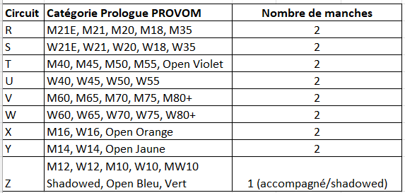
- Ranking based on the cumulative results of the 2 rounds completed in any order (except for : M12, W12, M10, W10, MW10 Shadowed, Open Vert : an unique round which can be shadowed)
- SPORTident Air+ punching will be used
- Flags 15cm x 15cm with control codes
- Possibility to register on site (depending on the maps available)
Organising team :
- Course director : Laurent Champigny
- Controller : Eva Jurenikova
- Course planner : Matthieu Puech
- GEC : Richard Heyries
- Map maker : Matthieu Puech
Distance parking – arena/event center : 400m
Distance Arena- Start : 0m
Distance Finish-Arena : 0m
Terrain :
- Mediterranean open or semi-open terrain
Be careful :
- Metal studs shoes forbidden (slab protection).
- Penalties
- Control less : MP
- Bad control : MP
- Control more : no penalty
Map :
- “Mazaugues, le val d’Aggas”
- Matthieu Puech (2024, 2027)
- Scale 1/1200 Equidistance 1m
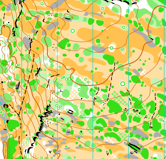
Map sample :
Circuits
A word from the map maker and course planner
A classic form of fun training, microSprints (or mSp for short) are very short, technical circuits with around ten controls on a highly zoomed-in map (usually around 1/2500). At this unusual scale, the obstacles appear very, very quickly, even when going slowly. This is what’s called overspeed.
To spice things up even more, this map has been specially designed for microSprint, so it includes far more detail than a standard 1:10,000 scale map. The map is at a scale of 1:1,200!!! This means that one centimeter on the map represents 12 meters on the ground (compared to 100 meters on a 1:10,000 scale map). At the same speed, elements arrive 10 times faster than usual, and there are also twice as many elements on the map as usual!!! Beware of brain overload.
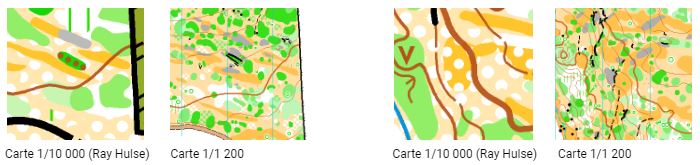
A good tip: on the first control of your first circuit, start by walking ! Seriously.
You’ll have plenty of time (and the chance to try) to speed up later, once you’ve got a good feel for the scale. Start slowly to really get a feel for the map, then gradually increase your speed if you feel confident.
Cartographic particularities
The drawing does not conform to the ISOM 2017 cartographic standard.
The rocks, for example, are generally just simple stones only 20-30 cm high.
No descriptions are provided : a small purple point in the center of the circle indicates the exact location of the control. To reassure those less experienced, the order numbers and their codes have been added to the top right of the maps.
Need you technical advices ?
Start by walking (really).
Focus on your compass reading at the exit of each control point.
Maintain good planning and direction despite the increased speed due to the high zoom level. Working on map-terrain relationship at overspeed means increasing your reading frequency.
Stick to the map, trying to stay one step ahead in anticipating the route.
This is proactive orientation (where am I going), not passive (where am I) or retroactive (where was I).
Try to find the right reading pace to always be ahead in your orientation.
Fun fact
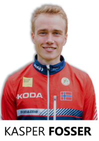
Kasper Harlem Fosser (Norwegian, World No. 1) tested one of the courses, but he lost 4 minutes at the first checkpoint by starting too fast.
Start by walking (really).